 Dark Ages Re-Creation Company


This paper was submitted on 6 September, 2011 to Wilfrid Laurier University as a requirement for a fieldschool credit after Karen and Neil attended this fieldschool. A more "social" discussion of this trip with many more pictures, and discussions outside of the strict archaeology can be found on our personal website.
For over 20 years a field school has been run on the Swedish island of Gotland under the direction of Dr. Dan Carlsson. Dr. Carlsson received his Ph.D. from Stockholm University in 1979. His thesis was "The development of the Iron Age Landscape on Gotland. A study of Continuity and Change." He is currently an adjunct professor in the Human Geography department at the Gotland University in Visby where he lectures on archaeology and human geography.
The field school has been involved in a number of very interesting digs including six years at the Fröjel site - a Viking Era harbor town. This site is estimated at 100,000 m2 of which only 1.5% has been excavated yielding over 40,000 artefacts. In each of the past three years, the school has investigated one multi-era house, usually with Migration and Viking Era occupation.
Additional staff for this year included Anna Pettersson (M.A Archaeology, University of Stockholm), and Astrid Lennblad (B.A. Archaeology, M.A. Osteology, University of Stockholm). The Hellvi site dig was led by Dr. Per Widerström from the Gotland Historical Museum.
Many facts presented in this report on conditions and archaeological norms on Gotland are not footnoted as they were distilled from the many conversations held between staff and students. These conversations were prevalent in the school and often involved discussing theories for why this or that feature appeared. Due to the nature of these conversations it would be difficult to correctly place any particular fact or theory on the person who offered it.
The field school is housed at the Gotlands Folkhögskola in Fårösund. The skola is an adult college housed in a new building on a military base that is no longer in use. This allows students to be housed in single or double rooms equipped with kitchenettes, full showers, and internet connections. Breakfast is provided at the skola, lunch at a hotel near the first dig site, and dinner at the local student hostel. Daily work begins at 9am and ends at 5pm. Lunch is an hour, and there are two breaks during the day.
An important element of this field school is that most students have attended for more than one year; three students have now attended for over 20 years. This year only 4 attendees, including myself, were in their first year. This impacts the lectures offered, excursion locations, and how the training is provided and will be called out in more detail in the sections below.
A total of 5 sites were excavated during this year's 22 day long school. Two were rescue digs, one was held in conjunction with a dig by the Gotland Historical Museum, and two were exploratory. The school also offered a comprehensive evening lecture program, and several excursions.
The school began with a background lecture on this year's primary investigative target - an attempt to locate a Viking Era harbor town inside the existing town of Slite, in Othem parish. The theory behind why a Viking Era town might exist in this area was documented by Dr. Carlsson in Petterson 2009.
Only a small number of harbor towns from the Viking Era are currently known on Gotland with most of them being found on the west coast. Given the transportation infrastructure of the period, there should be a larger number than have been found.
The site of Slite makes a good target for a number of reasons. There are multiple graves within the town, dating to the Viking Era which were excavated in the 1940s.
Two interesting notes on seventeenth century maps identify the place names Barlastplats [ballast place] and Gamla Hamn [old harbor]. Since these two locations are not near the current Slite harbor which was in use in the seventeenth century, it is more likely that they refer to an older harbor that might date back to the Viking Era.
This information was combined with the 2m rise in elevation due to isostasy since the Viking Era; and a review of maps to determine places where there has likely been no construction since 1600AD. Dr. Carlsson obtained permission from a number of landowners to dig in their yards. The conditions on those permissions, and the lack of other permissions, controlled our exact dig locations which can be seen in Figure 1 below.
The goal of these initial excavations was to identify the depth and parameters of the Viking cultural layer, and any graves or constructions that might be from the same period. Dr. Carlsson offered a bottle of champagne for the first confirmed find of a Viking Era coin. This added a fun element of competition between the teams, which unfortunately was not won.
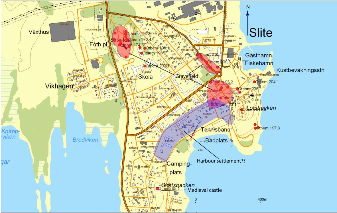
Figure 1: Map of Slite with tentative settlement location (Petterson 2009, fig 20). Image Copyright Dan Carlsson, 2009
Teams were assigned based on the number of weeks they would be staying, thus I was assigned to the four-week team. The most experienced team member was assigned as a trench master for each group. Our team consisted of six individuals two of whom had no experience. The other four had a combined total of 24 years with this school. Of our group I was the only one with formal schooling in archaeology.
At the dig site I had expected a lecture on digging techniques; however, it would have been redundant for the majority of the students. We were provided with all of the equipment needed and left free to work. This method is faster in putting the diggers to work, and in my mind makes the learning more immediate. Our trench master and the other experienced students led by example and were always available for questions.
I addressed the lack of a formal program by asking lots of questions. This teaching method does require willingness on the part of the student to speak up and take control of their education. Shy students simply will not learn as much in this environment since it is easy for the experienced diggers to assume knowledge where it may not exist.
A good example was the layout of our first trench, a 2m x3m rectangle. The other students simply took up digging, but I took the time to check with Anna to learn the reason for this shape. Since the presence of Viking Era graves was identified as one of the targets of our excavation, and since such graves are generally laid out on a north-south axis in Gotland a trench with a very long east-west dimension and small north-south dimension would be more likely to locate a grave. Anna's answer was simply that they weren't expecting graves at this spot and a broader area gave us a better chance to identify other features such as postholes. A little further north, the spot targeted for our group's second trench was closer to the previous graves and a different layout was used. If I had not taken the time to ask it is unlikely I would have learned this information.
Each person was assigned a 1 meter square as their primary responsibility; however the expectation was that the group was responsible for the entire trench. This was re-enforced during the dig as the team members regularly helped each other with sieving, or digging in the squares that were not complete.
The plan was to dig a sequence of 10-15 cm layers until some clear stratification was noticed allowing a shift to a stratigraphic approach. The soil column in Gotland is very shallow and very rich in finds. In total, we removed only 50-60 cm of soil to reach sterile sand. In the top 10 cm of soil column we found porcelain, glazed and unglazed pottery, burnt clay, flint shards, window glass and shaped glass, iron nails slag, and fish, bird, and pig bones. What stratigraphy did exist was so lightly defined that it was often only visible in the profile.
Also of note is that Gotlandic sites may see inundations of sand as a historic layer which can easily be mistaken for a sterile layer. As a result, we regularly took the time to dig rather deep (over 30 cm) test holes down into the sand to ensure that there was not a black earth layer further down. A previous year's dig encountered this situation with a cultural layer dated to around 2000 BC being found below a 30cm layer of sand that was under a Migration Era layer. Layer 1 of trench 1 was 10 cm of sod and plow zone consisting of hard packed clay based soil with the western 30 cm in pea gravel. My primary square was on the western edge which taught me that digging and sieving pea gravel is very annoying. Finds were registered at each layer. First the finds are briefly cleaned then they are sorted into groups for bone; flint; iron; ceramics (glazed, or unglazed but visibly shaped); glass; unshaped but baked clay; and any other items. Clay was weighed and thrown out. Bone was weighed and placed in a paper bag. Everything else was stored in plastic bags. Bags are labeled with the county and year, parish, street address, trench number (GO 2011 Othem; Mäsen 17; Trench 1), square number, layer number, and content type. Finds are gathered in the on-site trailer for safekeeping and later analysis. The find contents for each layer are then recorded in the trench binder, both as text in the description and on a separate sheet giving an X for each type of find which provides a good overview.
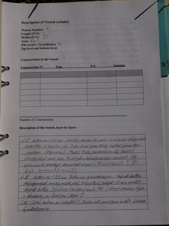
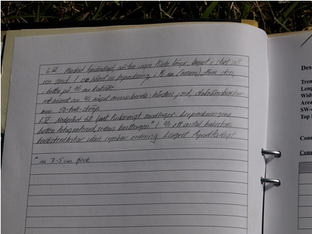
Figure 2: Trench notebook for GO 2011 Othem; Mäsen 17, trench 1. There were no constructions but short descriptions of each layer are included.
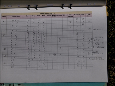
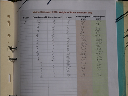
Figure 3: Tally sheets showing types of finds in each layer for each square (L) and weights of bone and clay finds (R)
Layer 2 was another 10cm of plow zone with the same type of soil as layer 1. The gravel stopped at 19 cm depth, but there was no sign of a pipe found. The gravel was clearly visible in the north, west, and south profiles indicating that it continued beyond what we had excavated but there was no visible change in depth. Although options including patios, pipes, and French drains were considered, it was not a Viking Era feature so it was recorded and ignored.
The difference in techniques used by the experienced diggers was interesting. To cut through the heavy soil they used a three pronged garden hand rake and a hand-hoe, in addition to scraping towards them with the lower point of the trowels. I found that sliding forward with a sharp archaeological trowel easily broke the surface allowing me to control the depth from 0.5 to 2cm. I felt that the force employed could be kept lower so when the point hit something it was easy to withdraw the pressure. I thought that pulling with the hoe or back edge would have caused more damage although the staff indicated that either technique, with experience, can control damage.
Due to the very hard soil and disturbed nature of the soil column, work on the western three squares was discontinued after layer 2. It was decided that if something interesting turned up we would go back and finish the western squares. In another 2 cm we broke through to a brownish sandy soil that was much easier to dig. Although this was a true layer, it was so shallow we proceeded though it. The brown sand lasted 5-6 cm then a layer of yellow sand appeared. We cleared the brown sand then decided to continue the layer through the yellow sand to a depth of 35 cm. In the northeastern corner of the trench the ground was harder. Looking at the results from lower layers it became apparent that we had a rubbish pit in that corner.
In layer 3 on the north western corner of the northern square we did find what would turn out to be our oldest find from this trench - a piece of early decorated ceramic later judged to be 10th to 12th century. We continued to find porcelain below that layer clearly displaying the very mixed nature of the soil column.
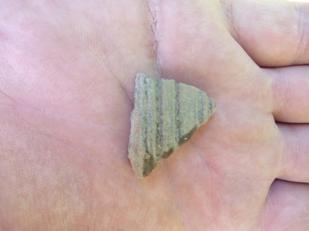
Figure 4: Decorated, unglazed pottery fragment from GO 2011 Othem; Mäsen 17; Trench 1; Square 2/1; layer 3.
Layer 4 was also planned for a depth of 15cm. The three active squares were cleared to that depth with the exception of the NE corner. The rubbish heap ended on a layer of hard packed clay which was left intact. At the bottom of the rubbish pit we had our first "Viking" find - two almost intact glass jars with the word "Viking" clearly impressed into the glass. Dr. Carlsson identified them as "Viking shoe cream" which was common in the late 1940s, giving us a likely date for the rubbish heap. In layer 4 the southernmost square became more interesting, first revealing half of a cow mandible, some bronze, and two medieval comb fragments. Some larger stones also appeared at the lower part of layer 4 and were left in place as they continued into layer 5.
Layer 5 was intended to be another 10 cm layer. We began by clearing in and around the hard packed clay base in the north east corner. The clay was broken with sand filling the gaps. The clay was photographed by the staff and then removed. Underneath was a thin layer of very hard soil. In this soil we found a piece of glazed ceramic which means that the clay itself cannot be particularly old - medieval at the earliest.
Below the hard soil was yellow sand which was quickly exposed in all of the other squares and determined to be the sterile layer. This determination was based more on recognition of the layer and depth than on clearing it to prove that it was sterile. We did run a couple of test holes down through the yellow sand to ensure that it was not just masking another cultural layer below.
I polished the North face and East face of the northern square for profile. Polishing is tricky in a sandy soil, and pretty much impossible in a rubbish heap with shards of glass and glass bottles sticking out every which way. We then measured and drew the profile.
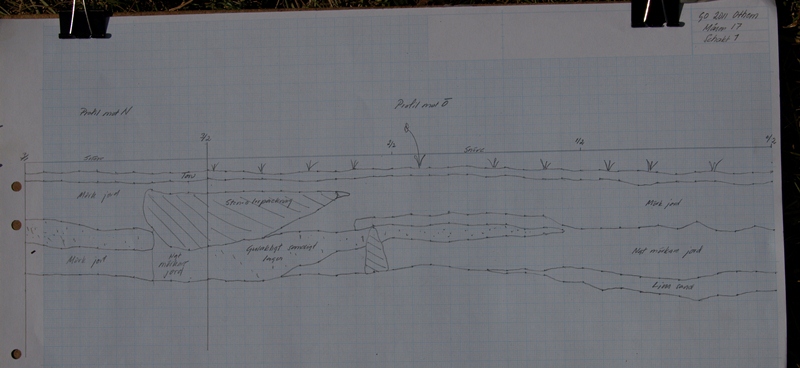
Figure 5: North and East profiles for GO 2011 Othem; Mäsen 17; Trench 1
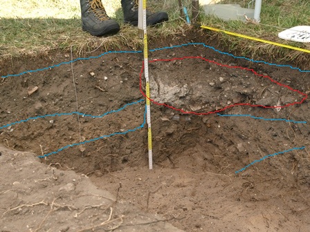
Figure 6: Photograph of north east corner of GO 2011 Othem; Mäsen 17; Trench 1 showing layers
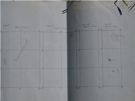
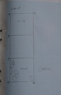
Figure 7: Layer drawings of GO 2011 Othem; Mäsen 17; Trench 1
Finds included a plastic button, what is likely a BBQ ash box, a lot of glass (window glass, bottles, two jars of shoe cream), iron nails and rivets, ceramics (shaped pottery, glazed pottery, and porcelain), various animal bones, a couple of very tiny clay pipe stem pieces, broken clay bits (possibly both pots and bricks), an 18th century Danish coin, an old bottle cap, and several kilograms of flint. No particular trend of materials by layer was apparent, with later porcelains being found in each of the top 4 layers.
After discussion with the staff archaeologists, the stones in the southern square were listed as a possible (but not probable) construction. The stones are lying flat where post holes in this area are usually created with the stones standing on edge. Especially with no likely Viking Era cultural layer this feature was not considered probable enough to open up the western squares to explore it any further. It was recorded in the layer drawings.
The rubbish heap in the North East corner was assigned a date of 1940-1950 based on the shoe cream and was not considered important enough to warrant excavating the remaining 75% of it that was outside the square. The likely medieval date of the clay base and the lack of anything similar in the other squares reduced its importance as well.
The large amount of flint was significant enough to provoke discussion. Flint is not found naturally in Gotland so this must have been imported. This trench was the closest of our trenches to the "ballast place" indicated on the maps which provided a likely source for the importation.
Given the very mixed nature of the soil column it was decided that finishing the western three squares would be unlikely to add value to the excavation. The trench was carefully closed and the turf restored.
A new trench designated trench 7 was laid out 17 m long on an east-west axis by 0.5 m on a north south axis. This trench was located to the north of trench 1 in the same yard and was closer to where three Viking graves had been previously found. The plan was to open a total of 6 m of the trench, 2 m at each of three spots. Unlike trench 1, the spoil of trench 7 was not sieved. Since the goal of this trench was to locate graves it was felt that sieving was not required.
We opened squares 0/0 and 0/1, and dug down to sterile sand at 50 cm depth. Each contained the same find types and poor stratigraphy as trench 1 but with almost no flint. There were no unusual features or finds. It was determined that a profile of this section would not advance the excavation goals so it was backfilled and closed.
The eastern section consisting of squares 0/16 and 0/17 began with 3cm of crushed limestone immediately under the sod, which proved difficult to dig through. Given the alignment of this section with a gate in the fence and outbuilding which might be an old drive shed in the yard this layer was likely an old driveway. The limestone covered the entire length of the trench except for a 40cm band approximately 40 cm from the eastern edge which was just hard packed soil. Below the limestone was a soil column containing the usual assortment of finds. A little further down was a very compacted clay - mostly in 0/17 but some spots in 0/16 as well. It was also missing the same 40cm strip noted in the limestone layer.
Immediately below the clay was a very thin black layer. A staff member was called in to examine it before we dug through it but no particular theories were advanced. The trench was continued down to sterile sand at 50 cm. Two test points were pushed down to around 80cm to ensure it was sterile.
The determination on the eastern section is that we had two driveways, one modern (the crushed limestone) and one older (the clay). The 40cm gap in the driveways was likely either a slot opened for a pipe, or the driveway was built as two tracks rather than a solid surface. There is a water well south and a little east of where we were digging so a pipe is possible, but we did not find it. This trench was closed as it did not advance the excavation goals.
The final section was 0/7 and 0/8 which dominantly contained the familiar soil column and the usual classes of finds. In 0/8 more of the clay layer was uncovered. The fact that we found a hardened clay layer in three of the four trenches we did in that yard at approximately the same depth never did get a good explanation. Since it was clearly not dated to the Viking Era it was not of primary importance to our excavation.
At 50cm depth, square 0/7 had a demarcation between the sand that filled the rest of the trenches and a brown earth. Even odder was that the demarcation matched the slightly north-east alignment that had been seen in a possible grave being investigated in trench 6 by another team.
It was decided to open an additional meter on the northern edge of 0/7. The expansion contained masses of rocks mixed with gravel and brown soil all the way down to 50cm. It was distinctly different from any other soil column we had worked with but seemed to be more like a backfill than a habitation layer. There were a few odd finds including concrete pipe fragments in 1/7, a bit of modern porcelain in the brown earth in 0/8 just below the 50cm depth and some modern blue glass at the bottom of 0/7. We decided that it was likely that we had a mixed/backfill situation, perhaps from a drainage system.
Since we failed to identify a Viking layer or any graves, we closed the remaining trench and marked that yard as completed.
Our trench group opened 10 m2 with 5 or 6 people working it for 10 days. Although there were lots of very mixed finds covering a period from around 1100 through 1950, in a mixed soil column there was nothing to indicate a Viking harbor site.
We did have a bit of excitement in one of the other group's trenches. Trench 6 produced what many quickly speculated might be a Viking grave. By the end of the second week, it was determined to be a well. Stylistically Dr. Carlsson believes it to be 18th century at the earliest. Neighbors suggest that it was filled in around 1920.
In total the field school opened a scattering of 38 m2 in various yards. There were interesting finds - a 16th century coin, an 18th century Danish coin, and a well. Where one team found a lot of flint and a little slag, others found a lot of slag and very little flint. Ceramics were everywhere but we had the only very early piece. Like our trenches described above, the other groups seemed to find little stratigraphy.
It is clear that although the maps may note little to no habitation in the 1600s there was clearly a number of different activities going on at various dates. A high concentration of slag indicated iron work, the abundance of flint an off loading point for boats, etc. Without good layers it is difficult to know whether to associate either with the medieval castle (1400AD) a kilometer away or any other time period.
Overall it is unlikely that a Viking harbor was in the area we surveyed. There are many other spots in Slite that could host a Viking harbor town but we didn't have consent to dig those areas, nor had a previous construction review of those locations been done. Further investigation will need to await another year.
As our trench group had finished in Slite a day ahead of some other groups we were re-deployed to assist in a one-day CRM project.
Dr. Carlsson had been called to do a survey of a field outside Burs in which the farmer wanted to add a crayfish pond. Dr. Carlsson did a map survey, finding no record of buildings. He also scanned the Swedish government database for known archaeological architecture and found no known features in the field. He then walked the field with a metal detector on 10 m lines and came up with 10 Viking Era silver coins in a small area. This approach is similar to the level 1 and 2 CRM survey required in Ontario. The major difference is that in Gotland they do not walk the field after plowing looking for surface artefacts. Dr. Carlsson mentions that they don't get good results from that sort of field walk so it isn't a requirement on Gotland.
Gotlandic law says that any more than 2 coins found together constitute a 'hoard' so a level 3 dig was required. Even when plow scattered, hoards tend to concentrate within 20 or 30 m2, limiting the scope of the required dig. The goal of this excavation was to find more coins if possible, and to hunt for postholes or other evidence of habitation.
Students walked the complete ground with the metal detector, digging and removing any hits while watching for post holes. The backhoe then removed 10cm of depth. The removed dirt was again scanned with the metal detector and any new finds removed. The freshly exposed ground was scanned and any finds removed. This was repeated until we hit the yellow sand which is the sterile layer. The soil was not sieved.
In all of the layers removed we saw no trace of a cultural layer. There were no postholes and no visible finds. We did find old plow marks cut 3-4 cm into the sterile layer. The sterile layer was 26 to 30 cm below the sod in the spots we profiled.
The original point source of the hoard was found, with at least 7 coins visible. We fully exposed it to sterile sand all around it. Dr. Michael Jonsson, a numismatist from Stockholm University arrived to assess the finds. He looked at each coin for a couple of seconds, and stated the country, king, and mint date range. All were dated between 980 and 1017 AD.
Dr. Jonsson dug out three coins and a possible bit of fabric (or very fine roots) but felt that more coins existed at a deeper layer. We dug a soil column around the hoard, wrapped it in a plaster cast and removed it as a single plug over 30cm deep. This column was excavated in more controlled conditions the next morning.
We learned that there had been another 20 coins buried in the top 2-3cm of the soil column. The latest coin in the hoard was dated to 1009-1017 so the hoard was assigned a tentative date of 1015-1020. The majority of the coins were English, although there were some Arabic, German, and Scandinavian coins as well.
In total the horde contained 70 coins and two small pieces of jewelry. It been placed 2-3 cm below ground level possibly in a piece of fabric. Some discussion ensued as to whether this was a misplaced pouch of coins lost in a field, or a sacrifice. The problem with the "loss" theory is that it was found 2-3 cm below ground level. The problem with the "sacrifice" theory is that at 2-3 cm below ground it would likely still have been visible, so why didn't someone else just take it?
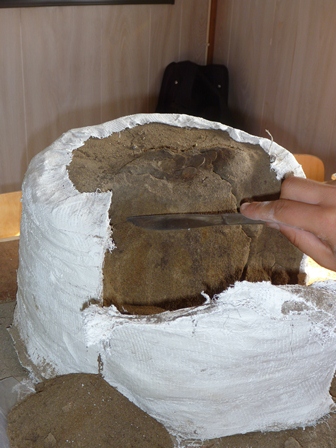
Figure 8: Photograph of profile of recovered hoard casting from Burs Site
Given the failure of the team to find a viable Viking Era site during our time in Slite it was necessary to find a secondary dig site for the remaining two weeks.
In April of this year a bronze mask was turned in to the Gotland museum by a person who had inherited it on the death of a relative. It had been found through metal detecting, which is illegal on Gotland, in 1980 in a corner of a known iron-age house (RAÄ 44:1) in the back fields near the church at Hellvi.
The mask was tentatively identified as a bronze roman gladiators mask (or ceremonial mask for an auxiliary legion) from c. 150 AD that was used in ceremonial parades. Given that the mask has an estimated value of $3M Cdn the museum funded a 10 man team under the leadership of Dr. Per Widerström for a week to look into the house. Unfortunately this team was only large enough to plan on opening a 1m trench covering two corners of the house, plus a single test meter in the middle of the house. Dr. Carlsson volunteered the 24 students, plus his staff to help for the remaining 2 weeks of our field school. The combined team would excavate all four corners plus some additional areas.
Our week began with this information as well as some additional background on Iron Age houses in Gotland. There are over 2000 Iron Age houses in Gotland but few have been excavated. Most Iron Age buildings are found in pairs with one large house and one smaller building. The Hellvi site has only a single building that is larger than average. The house is approximately 600m from the church through a number of fields with no other unexcavated sites of archaeological interest known to be on the property. During the course of our walking the fields each day two probable Bronze Age stone ship settings and a possible house were located.
The field school trench covered the entire west wall including an entrance, the inside 3m of the south wall, 3m of the north wall and 3m outside to the north of the house. My team's trench (trench 1) was outside the north wall. The squares were numbered 16/6 through 16/9 and 17/6 through 17/9. This group began about a meter north from the house wall rubble field. For the second week we also took on the 15/x and 14/x squares. Our hope had been to find a rubbish pile beside the house.
The ground was very dense with roots. When the site was originally surveyed in the 1950s it was covered in trees. They are gone now but roots (big and hair fine) are everywhere. On the eastern end of the trench was a feature that Dr. Carlsson identified as likely being created when a tree toppled to the north. This left a shallow soil to the south and a small hill to the north where the dirt had fallen from the roots. This feature is visible on the left edge of Figure 9. The ground is also very hard - and likely completely undisturbed.
The trench contained a feature that would impact our work. There was a wall of boulders running north from the north west corner of the house in our westernmost meter occupying most of squares 16/6 and 17/6. Most of the boulders were just underground, and the two we had thought were small rocks near the surface turned out to be big and stretched well below the surface. With the removal of Layer 1 the possible wall was more obvious (see Figure 10). Judging from the other rocks visible on the surface it appears the wall ran at least 15 meters out from the house. Throughout the excavation the areas between the boulders would yield the majority of interesting finds in our trench including the knife in Figure 12, and pottery in Figure 13.
Figure 9 shows the long walls of the house superimposed with horizontal black lines. The black arrow indicates the western entrance to the house. The blue line is the line of boulders forming a possible exterior wall.
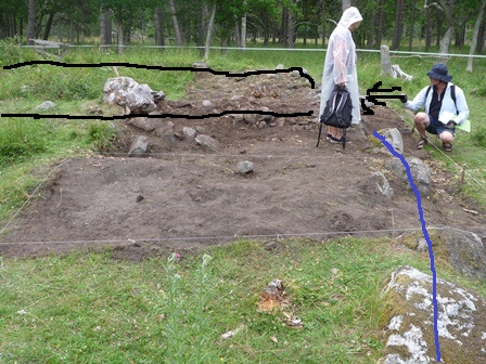
Figure 9: Edited photograph taken from just past the south west corner of trench 1; GO 2011 Hellvi RAÄ 44:1 looking east.
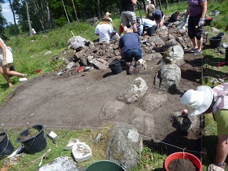
Figure 10: Photograph taken from just past the south west corner of trench 1; GO 2011 Hellvi RAÄ 44:1 looking east at the completion of layer 1
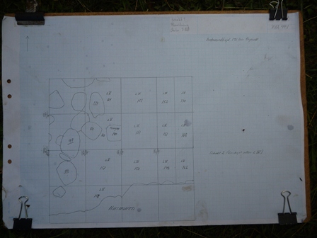
Figure 11: The final plan view of trench 1 and trench 2; GO 2011 Hellvi RAÄ 44:1 showing the possible exterior wall as well as elevations for each square and the layer to which the square was dug. The rubble from the house wall is visible at the bottom.
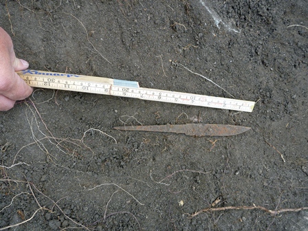
Figure 12: Probable migration era knife from square 14/6 of Go 2011 Hellvi RAÄ 44:1
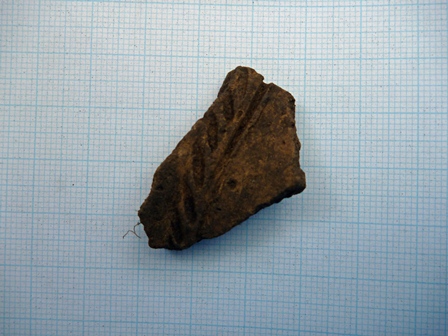
Figure 13: Probable migration era pottery from square 17/7 of Go 2011 Hellvi RAÄ 44:1
As with the Slite site we proceeded through a number of layers chosen for their depth as there was not enough visible stratigraphy. The entire trench was taken down to a common depth rather than taking each square down by a fixed distance. This meant that the first two layers were very limited in the 17/x squares.
Finds appeared right from the first 10cm layer including a lot of animal bones, and blackware pottery. Unfortunately the blackware is very hard to date being produced in Gotland from pre-roman Iron Age to the Viking Era. Animal bone played a large part in this trench especially in the x/7 squares east of the walls. At layers closer to the surface we brought up many rabbit bones while in the lower layers, horse and cow made a strong showing.
In layer 3 a soft area began to appear between 16/7 & 16/8 and 17/7 & 17/8. It was about 1.5 m long, running from a point in the north and widening out to perhaps 20 cm in the south. The ground was so soft that if you pointed the trowel down and let it go it would sink in more than a centimeter. Yet the ground beside it was very hard to scrape. In 15/7 and 15/8 something similar appeared but there it formed a ring with 10-15cm width wrapped around a hard core about 30cm wide. Given the bones from at least 3 different rabbits it was assumed that it was a warren that filled in. The soft area disappeared in layer 4 without revealing anything significant.
The staff archaeologists took photos of each square upon completion of layer 1 and layer 4. The photos were merged to create overhead shots of the work area for documentation to supplement the trench drawings.
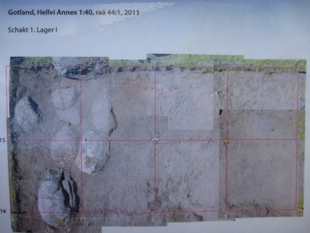
Figure 14: Photographic composite of trench 1, layer 1
At the end of the first week on the site the team working on trench two (squares 14/x and 15/x) left and our trench one team took over their squares. As we were still coming across finds in layer 4 it was decided to continue with a layer 5. Given the reduced staff in the combined trench 1 & 2 it was decided to dig only the x/6 and x/7 squares where the finds had been concentrated. The eastern half-meter of the /9 squares was also taken further down to allow the profile to be drawn.
A small boulder straddled the boundaries between 15/7 and 16/7 but by the end of layer 4 its lower edge was cleared indicating that it was not as thick as the other boulders. This was removed as we began layer 5. A small soil column supported the stone and was cleared first. Charcoal was found in this column, which I carefully removed and bagged it for future C14 dating.
At the same time the museum team also completed its week on site. Their trench at the eastern end of the site had not uncovered anything significant other than the usual finds and some post holes. The single square in the middle of the house which had been opened to explore the habitation layers, however, had produced significant finds and had been extended. In the rubble field from the inside of the southern wall a large amount of bronze and silver items were found. These included silver ingots with green discoloration indicating that the silver was debased. Silver embossed mounts for the open end of drinking horns and three bronze mounts for the closed ends were found. Additional finds included an arm ring, horn mounts, a large stick pin (seen in Figure 15) and many other pieces. As this is the only bronze/silver hoard of this approximate date found in Gotland it is extremely likely that it is related to the bronze mask.
For the second week, two of our four remaining teams were withdrawn from their squares and moved into the museum trenches to continue the investigations. Those investigations produced some more finds including a bone spindle whorl and a hearth, as well as a post hole containing some of the post.
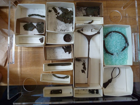
Figure 15: A portion of the finds of the Hellvi hoard
In my trench, layer 5 turned out to be very shallow as we hit the sand/gravel sterile layer quite fast on the southern edge, and not too much deeper on the northern edge. In 17/9 and a test area of 16/7 we pushed through the sand/gravel layer to come to a solid clay layer. In 16/7 we continued 30cm into the clay to confirm that there was no cultural layer below it. In layer 5 the finds included only animal bones, and a couple of pieces of very poor quality fired clay with very coarse tempering.
At the interface of layer 4 and 5 we did find something unusual. As you got close to the house the soil got very dense (hard enough to warrant digging in with the point of the trowel and breaking it open piece by piece). Under that was one to two centimeters of black earth, then the sterile sand/gravel mix. Figure 16 shows the border of 14/7 and 15/7 where this change in soil was apparent. Note that 15/7 has been dug to the sterile in layer 5 while 14/7 has only been taken to the end of layer 4. Dr. Carlsson determined that this was a possible result of animal trampling given the large animal bones found. It is possible that the exterior border wall was a pen for animals and that this point closest to the house was where they were funneled into the western door of the house. The other option that we discussed was that it could be a floor to an earlier building which had been removed when the current house was built.
Figure 16: Interface of 14/7 and 15/7 at the layer 4 and 5 interface (Go 2011 Hellvi RAA 44:1)
The profile wound up being extremely basic. There is the sod layer, a gray layer in trench 2 (squares 14/9 and 15/9) that vanishes almost as soon as it hits trench 1, mixed soil, and the sterile layer. After the x/9 and x/6 and x/7 squares were cleared to layer 5 I assisted in the drawing of the profile. We also employed the theodolite to allow the creation of a profile of the wall itself.
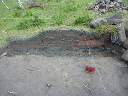
Figure 17: Northern profile of trench 1 & 2 of GO 2011 Hellvi RAÄ 44:1. Photo enhanced to show layers.
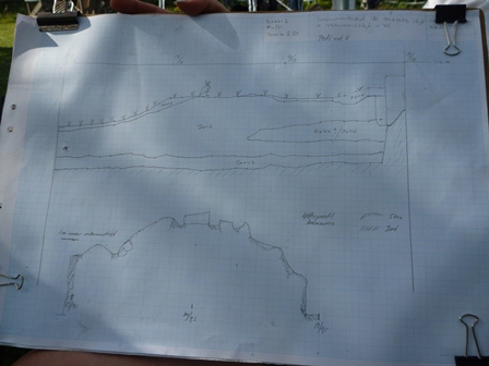
Figure 18: Profile drawing of northern profile for trench 1 and 2 of GO 2011 Hellvi RAÄ 44:1. Lower drawing is the profile of the wall section.
The preliminary results indicate that the bronze/silver hoard is late Roman Iron Age (200-400 AD) with the other finds likely from then through Migration period (400-550 AD). The Y shaped pin is dated 300-800 AD and is not Gotlandic in design. A wooden post was recovered for dendrochronological dating and C14 dating to go with the charcoal from 16/7. There were also traces of an earlier cultural layer under some of the floor stones and one or two possible signs that this house was built on the site of an earlier house. It is interesting that none of the four interior corners of the house showed a sign of previous excavations since this was supposed to be where the mask was found. The finds were significant enough that Dr. Widerström intends to try and mount a follow-up excavation next year to clear the rest of the house.
In the afternoon of July 20th our trench team was at loose ends. We had filled in our trenches and the other teams were not yet ready to back fill so we could not help them. Dr. Carlsson had two side projects in mind: a phosphate map of the area, or an investigation of a possible medieval house 200m away. Earlier, in walking the field we had noticed stones that seemed to form a square outline plus an internal structure that might have been the hearth. Dr. Carlsson had swept the area with the metal detector and received a lot of hits from iron.
It was decided that the house was more important. Permission was obtained from the Museum authorities to open a small test pit to determine the age and see if we could confirm it was a house. We ran a 1x2m trench through the area we anticipated was a wall of the house. This turned into a very shallow dig. Less than 15cm under the sod was a sand/gravel layer that matched the sterile layer we had seen in the Iron Age house.
We found lots of iron (nails mostly), ceramics, and some flint. The wall was very obvious and thicker than we had realized. The ceramics were mostly inside the wall with one small piece outside the wall. We also located what might have been some wood traces inside the wall. If they were wood then it was likely a wooden floor. The likely date based on ceramics was 1600-1750. According to the maps there wasn't a house there in 1695 so the date has been tentatively assigned as 1695-1750. A piece of clay pipe stem was found with an airway of 5/64" which provides a rough date of 1720-1750. That likely refines our date further towards the 1750 date.
Overall that was a good afternoon's work and will provide a framework if someone decides to dig the house later.
Two of our more experienced fellow students plus our osteologist had been pulled away in the third week to do rescue work on a pipe laying site that had hit Stone Age burials. I did not participate in this dig but include it for completeness on the types of work with which the school was involved.
In their first pass on the area the bulldozers uncovered was appeared to be 5 skeletons in 3 graves. Archaeologists were called in to investigate on a time critical call as the municipal requirement was that the construction had to begin again in 3 days.
The three person team excavated a total of 8 skeletons in five Stone Age graves. Grave 1 was an 18-20 year old male with a 6-7 year old child. Grave 2 a woman with a very newborn child placed between her legs. She was also holding the legs of a man who had been buried with her. This burial had a number of grave goods including two stone axes, a javelin, and a fishing hook.
The third grave was a single burial. The final grave was a body, apparently also with a young child. Dating for these graves was around 5000 BP. The last skeleton was uncovered 3 hours before the crew moved in to resume work.
Recovery instructions were to take the bones, any ceramics with decoration, and any other artefacts but ignore undecorated ceramics.
The first evening lecture was by Ph.D. candidate Christoph Kilger entitled "Viking Age treasures and female belongings". Currently hoards are split with coins stored in one location and examined by numismatists. Other artefacts are stored elsewhere and examined by archaeologists. Chris is a numismatist but wants to look at the hoards holistically. This allows a focus on total contents which allows us to ask about the purpose of hordes, for example, why are so many hoards just coin with a single snake pattern bracelet? We looked at the Spillings hoard as likely a cash deposit; Stora Velinge I hoard as an offering; Asarve hoard as a cache of raw material; and the Nygards Horde as an example of female wealth.
The second lecture was by Gunilla Runesson whose Ph.D. thesis will try to tie Bronze Age hoards, burnt mounds, and stone ships to settlements - none of which have yet been found. Generally mounds like the one at Lärbro were assumed to be inhumations for chieftains. Inside the Lärbro mound was a stone coffin with unburned bone and bronze as well as late Bronze Age and Viking graves. There are 380 stone ship settings on Gotland which are generally single cremations. A lot of fire cracked stone is found in or near these types of burials, often in mounds of their own. Gunilla's assumption is that some of the burnt mounds are domestic since she has found traces of post holes nearby. Other mounds are more like graves. In some cases there are settlement traces near the graves, and even re-activation of old mounds. Perhaps this is territorial in nature "our people are buried here so it is our land" or something similar.
Johan Norderäng and Margreta Christon spoke about the excavations in Västergarn and the field school there. Västergarn is downriver from Paviken and likely rose as the river to Paviken silted up around 1000 or 1100. Västergarn has a large stone wall built around 995AD that is 1 km long, 15 m thick, and 3 m high and built using Viking not medieval techniques. Previous digs confirmed medieval habitation but didn't turn up Viking Era artefacts. The assumption had been that the area was empty before the first church was built in 1150. From 2006 to 2011 the school has focused on locating Viking Era finds. They have excavated 775 m2 obtaining 650.2 Kg of bone, 447.6 Kg of iron and glass slag, 54.5 Kg of pottery and more than 1600 rivets including many Viking Era objects.
Dr. Michael Jonsson provided a lecture on Roman Coins in Sweden shortly after we met him at the Burs dig. 7689 roman denarii (dated 50-193 AD) were found in Sweden of which 6568 were found on Gotland. Only 817 Solidi (dated 450-550) have been found. In Sweden 252,784 Viking Era coins (800-1140 AD) have been found. Normal roman coin finds on Gotland are 3g silver denarii and various bronze coins. Coins minted after 190 are debased with copper - which matches the silver ingot we found at the Hellvi house. About 100 imitation coins have been found on Gotland struck by the Franks, Burgundians, Visigoths, and Ostrogoths. A total of 3.5 kg of coins have been found but 45 Kg of gold objects have been found with the biggest single objects being necklaces ranging from 615 to 820 g. The reason for the big imports of gold isn't known. There is an idea that it was a share of the tribute paid to the various tribes but there are no hoards matching any of the known tribute time lines. It has also been suggested that it was a trade item (perhaps for iron) but again the known timings don't work out. Overall this was a very good lecture.
Ph.D. candidate Joakim Wehlin provided an interesting way to look at Baltic stone ships. The first step is to divide the boats into 4 different types. The first group is built with stones just barely showing above ground. This type tends to have more than one burial and may be a family grave. The remaining 3 types tend to have one burial closer to the north end of the ship. The second type is entirely made of small stones. This is the type we located at Hellvi. The third type is made of large slabs but is only vaguely ship shaped. This group often has inhumation graves with knives. The final group is very well made using multiple different sizes of stones to get the shape correct. All four types seem to have the same basic dates. On rock art ships often have a circular companion. About 20% of stone ships also have an accompanying circular feature mostly without any burials. Joakim did excavate across the north end of one ship and part of the accompanying circle. The circle had two graves dated 630 years apart. There were also burned bones between the ship and circle.
Gustaf Svedjemo's lecture on his Ph.D. thesis about the Iron Age landscape on Gotland was the poorest of the series. Unfortunately he was not a good lecturer and was further hindered by a math heavy thesis, and talking about double his allotted time. He is trying to use predictive analysis on iron-age houses to understand settlement patterns. I'm comfortable with the math showing correlations such as the 84% correlation of Iron Age stone houses with moraine based soils - but it is so easy to drift into assuming that there is causation involved and the math doesn't give you that. Plus of course, such modeling just confirms what you already know. It won't point out to you any new finds that don't match (and hence might invalidate) the model involved. He was also unfocused in his lecture giving us a broader historical range than his thesis work would normally involve which didn't help his presentation.
The final lecture was Dr. Carlsson talking about the Eastern Connection - Scandinavia and Russia. He is consulting with a group of Northern countries to look at how to open the whole eastern Viking route to tourists. This is coupled with an academic push to include more of the eastern connection in the publications. The basic eastern story comes from the Nestor chronicle in the 12th c which documents the "invite" Rurik and his brothers got to come be the lords over the Russian cities and bring order. Rurik settled in Novgorod, Sineus in Beloozoro, and Truvar in Izborsk.
The trail would begin in Stararia Ladoga. There are excavated Viking graves and traces of a Viking fortress just across the river from the town. The artefacts start around 750 AD and include beads, tortoise shell broaches, and a mould for a Thor's hammer.
Moving down the river (past Novgorod for a moment) we come to Gorodische. This is the predecessor town to Novgorod likely being created around 850 AD. Since Rurik came in 862 he would have gone to Gorodische, but this is often glossed over.
Novgorod itself was created around 950 AD. Work here is interesting as each year they have an excavation that is fully open to the public (with covered viewing areas, and a public presentation area). The 10th century layer is very wet and 7 m down from the surface so logs and posts, as well as over 4000 birch bark messages survive.
At Izborsk Dr. Carlsson noted that at least one artefact he was shown had two matches found in a Gotlandic site. Pskov (nearby) has some Scandinavian graves found during hotel construction. At least one chamber grave was fully preserved. Apparently the hotel has a good display of the artefacts which were rather mixed, some Scandinavian some Russian. The link goes both ways - when nine male graves from Fröjel were genetically tested four had an eastern origin.
The first excursion was a day long tour including: the rune stone room and 1361 exhibit at the Gotland Museum in Visby; a collection of late Bronze Age stone ship settings; the Fröjel excavation site; Vallhagar Iron Age settlement and the reconstructed houses at Gervide; one of the many picture stones; and one of the four abandoned parish churches. The final excursion covered three additional sites of interest. The first was Trullhalsar which is a big grave field with hundreds of graves dated from migration through Viking Era. This provided us an opportunity to examine changes in grave patterns over time. The second stop was Tjelvar's grav, another stone ship setting and the attached hill fort of Fornborgar.
The second and third excursions were to possible sites for future field schools and focused on field-walking techniques.
The first site was File, a farm through recent historical times but now abandoned. Nearby is Litla File which was abandoned in the 1500s. We did a field walk trying to locate traces of Litla File and found several tentative stone buildings. We also looked at contours and possible field use patterns which was interesting to learn. The next step for this site will be to return in spring when there is less vegetation with a Total station to map out the possible buildings and compare them to 16th, 17th, and 18th century maps. Following that phosphate mapping would be helpful in choosing target areas. Ground penetrating radar (GPR) is useless here due to the very thin soil over limestone bedrock.
Magnetometry and resistivity don't seem to be common on Gotland likely more for social reasons from what I can gather. We did find an interesting stone feature (Figure 19) consisting of two rows of stones in a gently curving path that stretched for more than 100m. Our discussion concluded that a road is the most likely explanation.
Figure 19: Possible medieval road at File
The second tentative site is a field near Lärbro. This field is a good candidate as the area has everything from the Stone Age to medieval sites registered but not dug. Our group focused on trying to spot Stone Age grave mounds (the red areas in Figure 20). Other teams focused on finding signs of the Iron Age (blue), or Viking Era (green), and medieval (yellow) constructions.
Like the experience at File the teams were mostly successful in finding elements that we feel are worth excavating but it would be useful to follow up the field walking with proper mapping, and phosphate testing. I am also not sure of the feasibility of exploring a Stone Age grave mound in a 4 week field school. When the mound of rocks can be over 3m across and a meter or more in height the work of the excavation seems to me to require more time than is available.
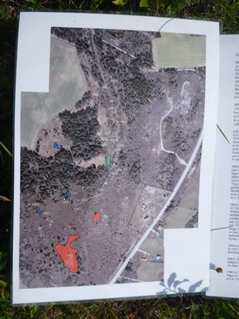
Figure 20: Map of Lärbro area showing known sites of archaeological interest
One advantage to this field school was that it allowed me to extend my research on Viking Era glass beads. Several hundred beads were found during the Fröjel excavations but only approximately two hundred without physical measurements have been published. As an extension to the course Dr. Carlsson brought out 211 previously unpublished beads and fragments for me to examine, measure, and photograph.
The resulting spreadsheet will be used over the next several weeks to match these beads to the typography created by Callmer (Callmer 1977). Where such beads match it may be possible to add more dating information to the Fröjel site. Where they do not match the typography may be extended to include them. The photographs and physical data will likely serve as the basis for an expanded re-publication of the bead material as a joint publication between Dr. Carlsson and me.
Due to a lake of stratigraphy the Fröjel material is only loosely datable. Material evidence gives a habitation range of 500-1180 AD. The beads may thus only be placed in this range. This is unfortunate as, like many other materials in Gotland, some Fröjel beads show unusual if not unique patterns. The bead in Figure 21, for example, has no peer for shape of which I am aware. The pattern of decoration is found on other Viking Era beads and since it is applied after the basic shape is in place this design must be the result of a deliberate choice on the part of the bead maker.
The data gathered support the observation from my 2009 research that almost every bead has a tapered mandrel hole. Of the 153 beads measureable for taper only 2 were straight. The others showed a taper averaging 0/25mm over the length of the bead (7mm on average). The Icelandic and Fröjel material tested so far would tend to indicate that the Viking Era bead makers used tapered mandrels unlike modern bead makers. The only published mandrel is from Ribe (Bencard et al 1990) and is tapered. Lundstrom mentions a mandrel from Paviken but did not include a picture or measurements (Lundstrom 1976). I was able to view this mandrel at the museum and confirm that it is also tapered.
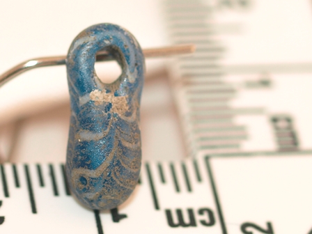
Figure 21: Unique pendant bead from Fröjel site
In 2009 I had observed that mandrel openings were more oval than circular. The Fröjel data confirms this over a much larger sample size. With an average opening of 3mm the semi-major and semi-minor axis show an average difference of 0.25 mm. This shape will have an impact on the bead making process. Modern experimenters using cylindrical mandrels often remove beads with a twisting motion. With a more oval cross section such a twisting motion would likely break the bead rather than releasing cleanly. The method used by Turkish bead makers today of hitting the bead off a tapered mandrel seems like a good candidate.
The experience at this field school sharply pointed up both strengths and weaknesses of Laurier's archaeology program. Courses that were immediately and specifically useful to me on this excavation included AR 220, 242, 244, 246, 313, 336, and 341.
The osteology course helped with recognition and discussion of the faunal remains. An additional lab focused on bone in a variety of degraded states, especially including waterlogged to aid in recognition would have been of significant value to me. At the Hellvi site we found many water damaged bones and others may have been thrown away under the assumption that they were wood.
AR242 was particularly useful due to the time in labs reviewing a wide range of materials (ceramics, iron). The technique Laurier employs of reviewing materials specific to cultures in related courses like AR242 could be complemented with a class on materials recognition for cultures not covered in the other courses. I was exposed to Roman Iron Age, Migration, Viking Era, and Medieval, in addition to later materials.
AR 244, 246, and 341 (Physical sciences, Environmental archaeology, and analytical archaeology) provided a welcome background in dating methods, and as a complement to the field walking exercises. In addition an understanding of types of trenches and the use cases around each aided me in discussions at the Slite site. I also found the knowledge of how AMS dates from charcoal can be contaminated to be of value in removing charcoal samples at Hellvi.
The tools and technology class (AR 313) exposed me to a variety of the materials we would find as well as the techniques that might impact them.
Being familiar with CRM digs through AR336 allowed me to compare the Ontario process to that used in Gotland during the two rescue digs in the field school.
In my bead research I have always dealt with beads of well documented materials. The Fröjel artefacts did not show the base material and the database is not easily accessible. This left me to differentiate among beads made of stone, amber, glass, bone, rock crystal, and metal by eye. A lab providing practice in this form of recognition would have been of significant value to me.
The field school has a strong advantage in the years of experience each digger brings to the trench. At the same time the lack of formal education does show in their distance from the use or implications behind the materials and processes being discussed. This could be remedied by arranging some of the evening lectures to cover topics like dating methods, bone identification, ceramics styles, and trench design. This would have an added advantage of being new to many of the participants on the excavations.
A final communication is sent out by the field school each spring with the formal report submitted from the year's excavation and a plain language summary. I am looking forward to receiving this material especially around the Hellvi excavation.
In past years the course has offered a two week extension on post-excavation analysis. This course was not popular and was not offered this year. The intention was to roll the material into the 4 week course on an on-going basis with any bad weather days being focused on this work. In total we lost only one half-day to weather on this dig. Although we did take time to provide a preliminary cleaning to the finds before they were registered, I feel that there were steps that were not covered in our course. Setting aside a cleaning station and computer to file the results and rotating the staff through the station for even a day each would add a significant amount of training. It was likely that had I asked this opportunity would have been offered to me but like my trench mates I found myself focused on the immediate work of getting the trenches completed rather than the follow up activities.
My intention is to return to this school next year. My new contacts should allow me to arrange a one week research period at the museum investigating the remaining Fröjel material and related material from Paviken and Västergarn. My intention is to follow that up with an additional 2 weeks of excavation to re-enforce the skills I learned this year.